Town Master Plan
Banur (2031)
Approximate map coordinates: 30.5541, 76.7195
This town/region is covered by a GMADA master plan. The documents below — the actual zoning, land-use, and planning detail — are hosted on and served directly from gmada.gov.in.
Proposed Land Use Plan
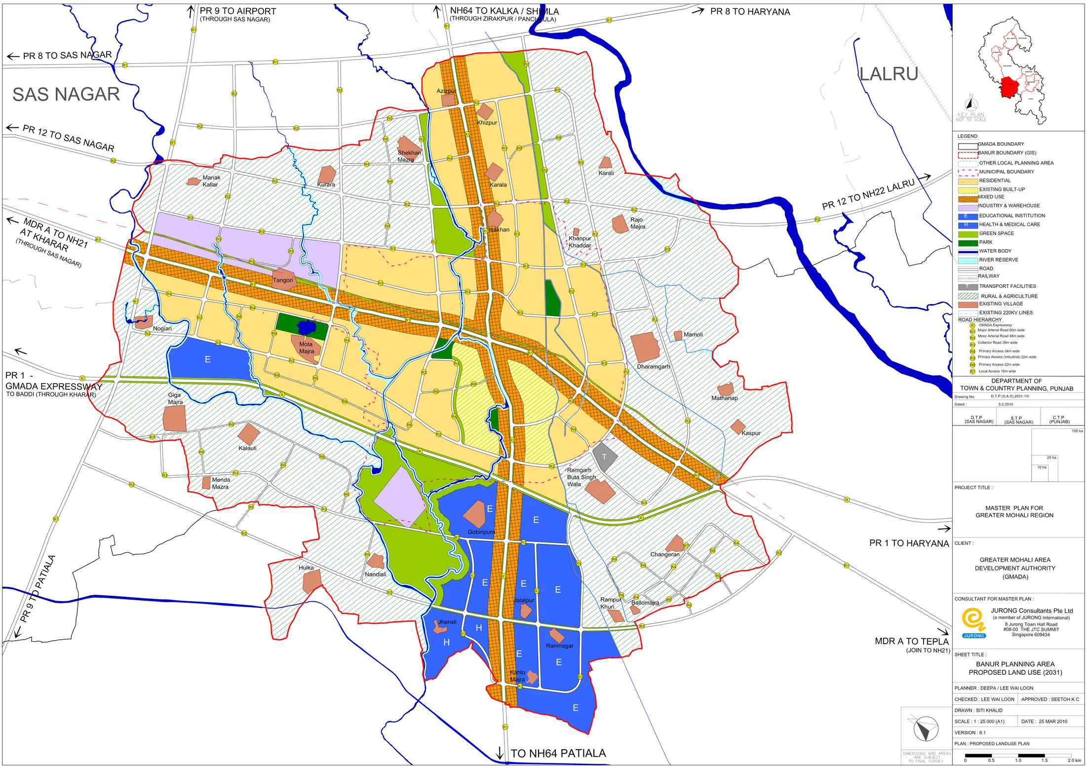
Extracted directly from GMADA's own proposed land-use drawing for Banur (2031) — click to open full size. Colours follow the plan's own legend (residential, industry, institutional, green space, and so on); see the "Reading the Plan" section below for what each one means.
Real Master Plan Documents
Master Plan
1.04 MB · PDFMaster Plan Report
25.4 MB · PDFRevenue Master Plan
6.01 MB · PDFWhat the Banur Master Plan Covers
GMADA's master plan for the Banur Local Planning Area (LPA) covers the period 2006–2031, one of six LPAs — alongside Dera Bassi, Kharar, Mullanpur, S.A.S. Nagar, and Zirakpur — studied under GMADA's 2007 integrated master planning exercise for the Greater Mohali Region. The consultancy was awarded to JURONG Consultants Pte Ltd of Singapore on 22 June 2007, working alongside the Punjab Urban Development Authority (PUDA) and the Centre for Computational Engineering at Punjab Engineering College. The accompanying land-use drawing (Drawing No. D.T.P (S.A.S) 2031/10) was approved by Punjab's Department of Town & Country Planning on 5 February 2010.
Three documents are on file for Banur: the 118-page master plan report, the proposed land-use drawing (A1 size, 1:25,000 scale), and a separate revenue master plan. All three can be downloaded from this page in their original form.
Existing Conditions and Planning Targets
As of the Census 2001 baseline the report works from, Banur's municipal area had a population of 15,013 — 36.1% (5,426) urban and 63.9% (9,587) rural — making up only about 2% of the Greater Mohali Region's total urban population at the time. Almost 92% of the LPA's land was in rural and agricultural use, with the population dependent on the primary sector; the existing built-up municipal area, at the intersection of NH 64 and MDR A, covered 104.1 hectares, with pharmaceutical and distillery industry concentrated in the town's western portion alongside a treatment plant for their effluent.
The plan assumes a very-high-growth scenario, projecting Banur's population to reach 119,558 by 2031 and 398,526 by 2056, driven partly by the Banur–Zirakpur Corridor's expected employment growth. Under this target, residential use becomes the single largest land use at 18.1% of the LPA's total area, followed by institutional use at 8% — part of a deliberate push to develop Banur into an institutional town with medical colleges and research institutes — and open space/parks at 6%. Industrial use is planned at 2.4% of the LPA's area, and residential density is targeted at a comparatively low 100 persons per acre (220 per hectare) to keep the area's park-like character.
Roads, Villages, and Phasing
The road network follows GMADA's standard regional hierarchy: a GMADA Expressway, major arterial roads (60m wide), minor arterial roads (48m), collector roads (39m), primary access roads (34m, or 22m for industrial access), and local access roads (16m). The plan connects Banur to NH64 toward Kalka and Shimla via Zirakpur and Panchkula, to NH21/NH22 via Kharar and Lalru, and to Baddi via a GMADA Expressway spur, alongside the two roads — NH 64 and MDR A — that already run through the existing town. An existing 220kV transmission line corridor also runs through the planning area.
Development is planned in two phases rather than all at once: by 2031, 46% of the LPA's land (4,782.5 hectares) is to be developed; by 2056, that rises to 62.1% (6,446.1 hectares), with the remainder staying rural/agricultural. The report frames this as a market-led approach — beyond essential infrastructure, development is meant to be led by the private sector or public-private partnerships rather than the authority itself. Villages named on the accompanying land-use drawing include Azizpur, Khizpur, Shekhan, Karali, Manak, Kallar, Kurara, Karala, Isakhan, Khanpur, Tangori, Ramgarh, Kaspur, Gobinpura, Nandiali, Jalalpur, Ramnagar, and Kahlo Majra.
Reading the Plan
The land-use drawing is a large-format engineering plan rather than running text — reading it against its own legend (land-use categories by colour/letter code, road widths by the classification above) is the fastest way to place a specific parcel. The master plan report covers the same ground in narrative form, including the special development controls — setbacks, floor-area ratios, height limits, parking provision, and more — that apply specifically to residential and institutional land within the Banur LPA.
As with every document on this portal, treat this as a reference copy of GMADA's planning intent rather than a live record — always confirm the current, in-force version and any amendments directly with GMADA before relying on it for a specific parcel or transaction.