Town Master Plan
Kharar (2031)
Approximate map coordinates: 30.7463, 76.6469
This town/region is covered by a GMADA master plan. The documents below — the actual zoning, land-use, and planning detail — are hosted on and served directly from gmada.gov.in.
Proposed Land Use Plan
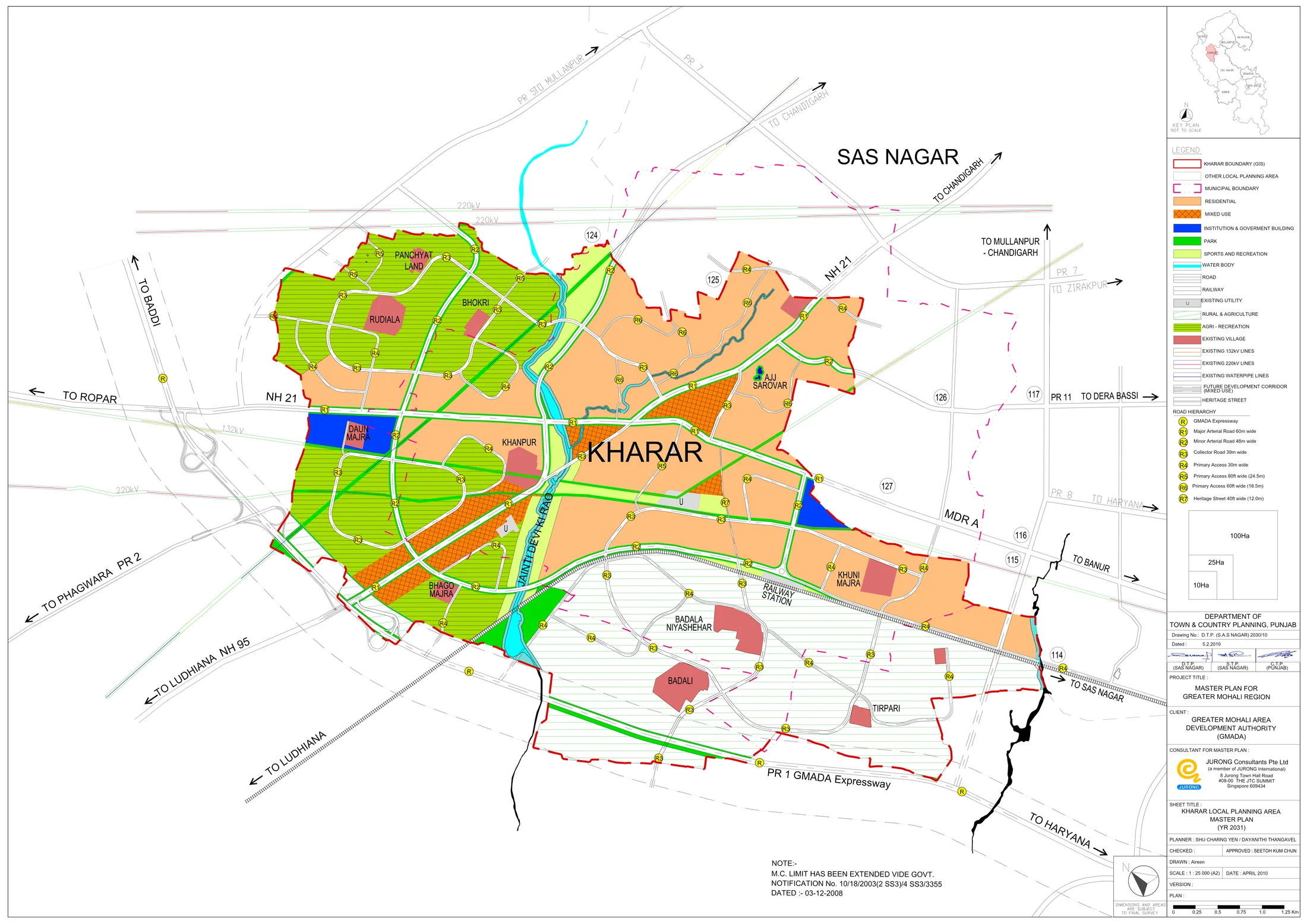
Extracted directly from GMADA's own proposed land-use drawing for Kharar (2031) — click to open full size. Colours follow the plan's own legend (residential, industry, institutional, green space, and so on); see the "Reading the Plan" section below for what each one means.
Real Master Plan Documents
Master Plan
546 KB · PDFMaster Plan Report
15072 KB · PDFRevenue Master Plan
2062 KB · PDFWhat This Master Plan Covers
GMADA's master plan for the Kharar Local Planning Area (Year 2031) was prepared by JURONG Consultants Pte Ltd, the same consultant behind Banur's and Mullanpur's plans from the same era. The drawing carries Drawing No. D.T.P.(S.A.S NAGAR) 2030/10, dated 5 February 2010, drawn in April 2010 at a scale of 1:25,000, with the municipal committee's limits separately extended by a Punjab Government notification dated 3 December 2008.
A Source-Document Note
GMADA's own site lists a separate "Master Plan Report" for Kharar alongside this drawing, but the linked file currently serves an unrelated document — a corrigendum concerning Jalalabad Town's local planning area in Fazilka district, not Kharar. This looks like a mislinked file on GMADA's own server rather than anything wrong with the plan itself, so rather than invent Kharar-specific report content that isn't actually verifiable from that link, this section stays limited to what the land-use drawing itself shows.
Roads and Geography
The plan places Kharar within GMADA's standard road hierarchy, with the PR-1 GMADA Expressway running through the area toward Baddi, and connections toward Ropar, Phagwara, and Ludhiana. The Jainti Devi Ki Rao, a local seasonal stream, is marked running through the planning area, alongside the usual mix of residential, industrial, institutional, and green-space zoning GMADA applies consistently across its master plans.
Reading the Plan
The drawing is a large-format plan best read against its own legend for land-use and road-width codes. As with every document on this portal, treat this as a reference copy of GMADA's planning intent rather than a live record — always confirm the current, in-force version and any amendments directly with GMADA before relying on it for a specific parcel or transaction.