Town Master Plan
Mullanpur
Approximate map coordinates: 30.7990, 76.7430
This town/region is covered by a GMADA master plan. The documents below — the actual zoning, land-use, and planning detail — are hosted on and served directly from gmada.gov.in.
Proposed Land Use Plan
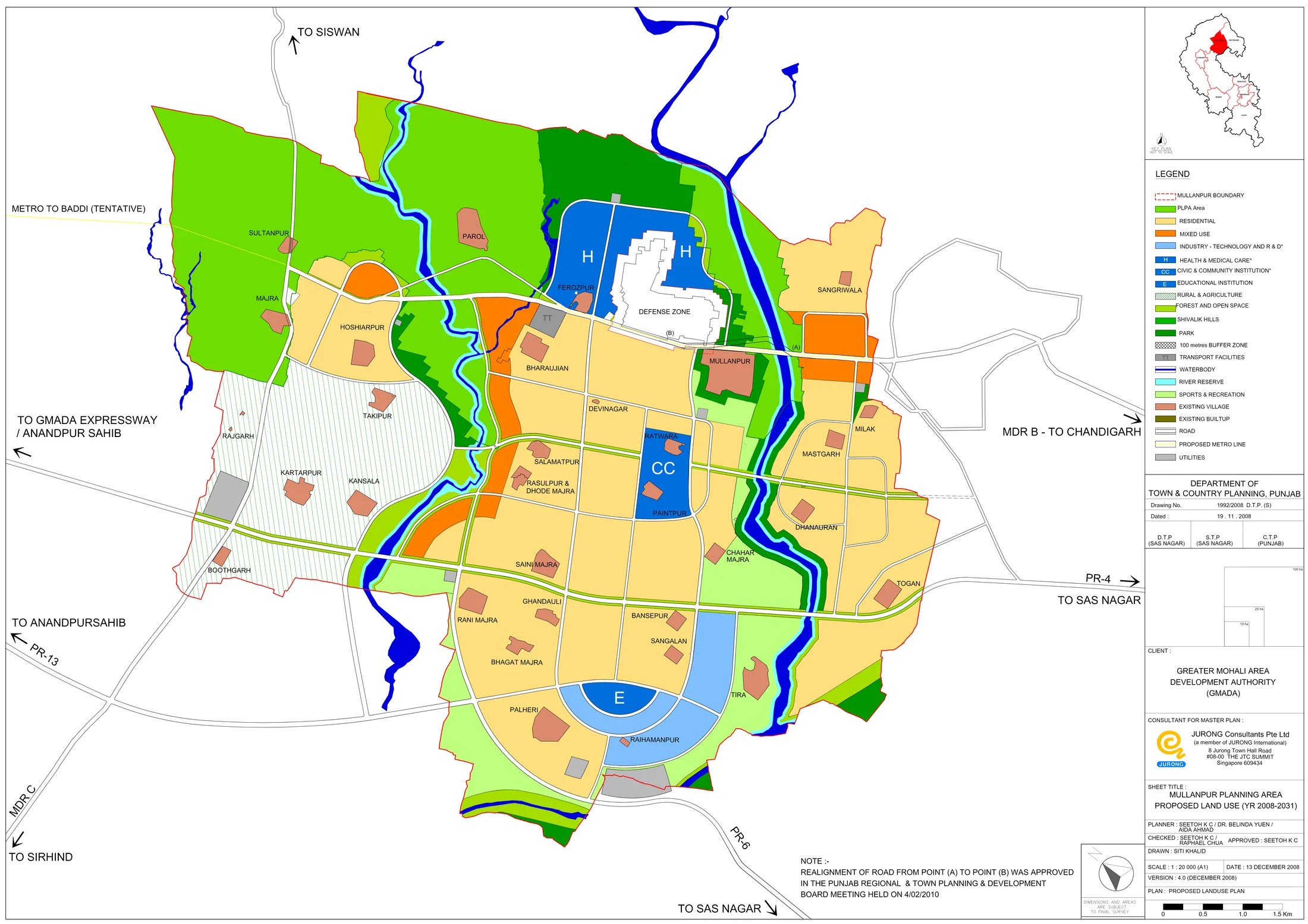
Extracted directly from GMADA's own proposed land-use drawing for Mullanpur — click to open full size. Colours follow the plan's own legend (residential, industry, institutional, green space, and so on); see the "Reading the Plan" section below for what each one means.
What This Master Plan Covers
Mullanpur's master plan (2008–2031) was prepared by JURONG Consultants Pte Ltd as one of six Local Planning Areas — alongside S.A.S. Nagar, Zirakpur, Kharar, Banur, and Dera Bassi — studied under GMADA's original integrated master planning exercise for the Greater Mohali Region. The plan sits at the foothills of the Shivalik range, bounded by Chandigarh and S.A.S. Nagar, and close to the industrial town of Baddi in Himachal Pradesh.
Vision and Population Targets
The plan's vision leans on Mullanpur's scenic qualities — its foothill location, intertwining rivers, and waterbodies — while also proposing a "technology-knowledge-business park corridor," described in the report as an Instructional-Knowledge Belt. Under GMADA's very-high-growth planning scenario, Mullanpur's population is projected to reach 200,000 by 2031 and 350,000 by 2056.
At the time of the report, the LPA still had scattered rural settlements and active brick kilns — both of which the plan treats as existing conditions to be worked around rather than erased outright.
From Mullanpur to New Chandigarh
This Local Planning Area is the same one GMADA later developed and marketed as New Chandigarh, including the Eco City phases referenced repeatedly elsewhere on this portal's notices and tenders — the villages named in those newer records (Sangla, Bansepur, Teeda, Chadmajra, and others) sit within this same Mullanpur LPA boundary.
Reading the Plan
Two documents are on file for Mullanpur — this master plan report and the proposed land-use drawing — both downloadable from this page. For the more detailed, later zonal plan covering the same area under its New Chandigarh branding, see that page separately on this portal. As with every document here, treat this as a reference copy of GMADA's planning intent rather than a live record — always confirm the current, in-force version directly with GMADA before relying on it for a specific parcel or transaction.