Town Master Plan
Dera Bassi
Approximate map coordinates: 30.5868, 76.8464
This town/region is covered by a GMADA master plan. The documents below — the actual zoning, land-use, and planning detail — are hosted on and served directly from gmada.gov.in.
Proposed Land Use Plan
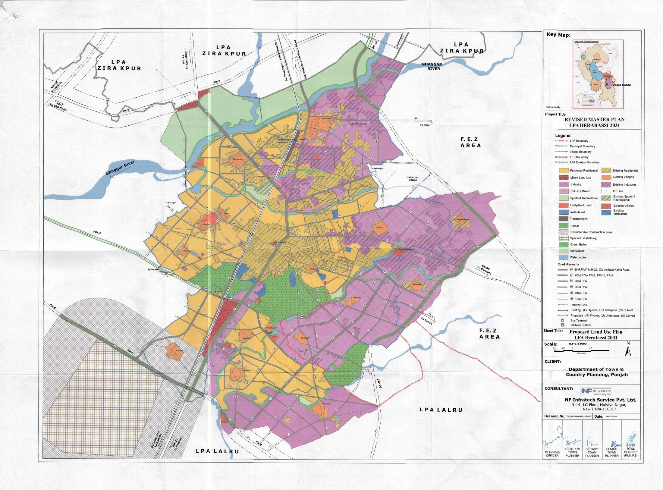
Extracted directly from GMADA's own proposed land-use drawing for Dera Bassi — click to open full size. Colours follow the plan's own legend (residential, industry, institutional, green space, and so on); see the "Reading the Plan" section below for what each one means.
Real Master Plan Documents
Master Plan
7.29 MB · PDFMaster Plan Report
3.89 MB · PDFRevenue Master Plan
8.42 MB · PDFWhat This Master Plan Covers
This is the Revised Master Plan for the Dera Bassi Local Planning Area (2015–2031), prepared by NF Infratech Service Pvt. Ltd of New Delhi for Punjab's Department of Town and Country Planning, updating an earlier plan drawn up by JURONG Consultants around 2010. The revised drawing carries Drawing No. DTP(SAS NAGAR)2281/16 and is dated 6 December 2018.
Three documents are on file for Dera Bassi: this master plan report, the proposed land-use drawing, and a separate revenue master plan. All three can be downloaded from this page in their original form.
Land Use and the Free Enterprise Zone
The town's growth is shaped in part by a declared Free Enterprise Zone (FEZ) that borders the LPA on its eastern and southern sides — a real, existing economic zone the plan works around rather than through. Under the earlier master plan's projections, accommodating a population of roughly 125,750 was estimated to require about 966 hectares of urban land, with a further 1,378 hectares set aside for industry — split between 991 hectares of standard industrial use and 388 hectares of mixed industrial use, reflecting how much of Dera Bassi's growth is expected to stay industrial rather than purely residential.
The road network follows GMADA's standard hierarchy, running from 60-metre rights-of-way along NH-22 (the old Ambala–Kalka road) and PR-8/PR-10/PR-11, down through 45m, 30m, 24m, and 18m local roads. The proposed road network alone accounts for roughly 347 hectares of land.
Neighbours and Geography
Dera Bassi sits between the Zirakpur and Lalru planning areas, with the Ghaggar River running along part of its boundary. The plan marks existing residential, industrial, and mixed-use zones alongside forest, agriculture, sports and recreation, and institutional land, plus a marked Restricted/No-Construction Zone and a Special Use (Military) area — both real constraints on where development can go, not just planning categories.
Reading the Plan
The drawing separates existing land use from proposed land use in its legend, and marks road widths by right-of-way rather than by name — cross-reference the road-hierarchy table on the sheet against the actual road you're checking. As with every document on this portal, treat this as a reference copy of GMADA's planning intent rather than a live record — always confirm the current, in-force version and any amendments directly with GMADA before relying on it for a specific parcel or transaction.